Airport Master copy 3 inchPHONE 903.768.2100

FAX 903.763.2550


Mineola / Quitman, Texas

Physical Location:  311 County Road 2355, Mineola, Texas 75773

Website:  www.WoodCountyAirport.net


airportfuelprice wcaairportservices wcacontactinfo airporthistorywebbadge  


 Runway 18/36 Information & FUEL


Dimensions: 

4001 x 60 ft. / 1220 x 18 m

Surface: 

asphalt, in EXCELLENT condition

Weight bearing capacity: 

Single wheel   12.5: 

Runway edge lights: 

medium intensity


RUNWAY 36

RUNWAY 18 

Latitude: 


32-44.202417N

 32-44.861670N

Longitude: 


095-29.802983W

 095-29.772547W

Elevation: 


433.0 ft.

 402.5 ft.

Gradient: 

    0.8% UP

Traffic pattern: 


left

 left

Runway heading: 


356 magnetic, 002 true

 176 magnetic, 182 true

Markings: 


nonprecision, in good condition

 nonprecision, in good condition

Visual slope indicator: 

    2-light PAPI on left (3.00 degrees glide path)

Touchdown Point: 

     yes, no lights

Obstructions: 


15 ft. trees, 350 ft. from runway, 225 ft. right of

centerline, 10:1 slope to clear

 58 ft. trees, 1653 ft. from runway, 25:1 slope to clear

  Airport LOCATION  

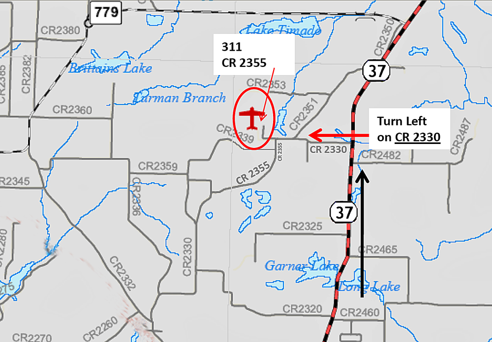
311 CR 2355, Mineola, Texas 75773

(Halfway between Mineola and Quitman)

MapAirportInsetWEB2012

FAA Identifier: 

JDD:  The Wood County Airport, Texas is located five nautical miles (9 km) north of the central business district of Mineola, Texas, and 4 nautical miles (7 km) southwest of Quitman, Texas, and 23 nautical miles north of KTYR Tyler Pounds Field.

Lat/Long: 

32-44-31.9300N / 095-29-47.3100W
32-44.532167N / 095-29.788500W
32.7422028 / -95.4964750
(estimated)

Elevation: 

434 ft. / 132.3 m (surveyed)

Variation: 

06E (1985)

From city: 

5 miles N of central business district of the associated city
(04 NM SW OF QUITMAN.)

Time zone: 

UTC -5 (UTC -6 during Standard Time)

 Airport COMMUNICATIONS 

CTAF/UNICOM: 

122.8

WX AWOS-3: 

118.9 (903-768-3065)

LONGVIEW APPROACH: 

128.75 [MIDLAND 0600-0000 SAN ANGELO 0600-2100]

LONGVIEW DEPARTURE: 

128.75 [MIDLAND 0600-0000 SAN ANGELO 0600-2100]

APCH/DEP SERVICE PRVDD BY FORT WORTH ARTCC 

FREQS 132.85/360.75 (CUMBY RCAG)

WHEN LONGVIEW APCH CTL CLSD

 
wcaprop

Nearby radio navigation aids


VOR name


Freq


Var

UIM r210/10.6


QUITMAN VOR/DME


114.00


08E

TYR r343/23.7


TYLER VOR/DME


114.20


06E

SLR r167/27.5


SULPHUR SPRINGS VOR/DME


109.00


08E

Other nearby airports with instrument procedures:

3F9       Mineola Airport-Wisener Field (4 nm S)
F51      Winnsboro Municipal Airport (16 nm NE)
KTYR   Tyler Pounds Regional Airport (24 nm S)
KSLR    Sulphur Springs Municipal Airport (26 nm N)

KJXI    Fox Stephens Field - Gilmer Municipal  
 
 Airport OPERATIONS

Airport use: 

Open to the public

Activation date: 

11/1983

Sectional chart: 

DALLAS-FT WORTH

Control tower: 

no

ARTCC: 

FORT WORTH CENTER

FSS: 

FORT WORTH FLIGHT SERVICE STATION [817-541-3474]

NOTAMs facility: 

JDD (NOTAM-D service available)

Attendance: 

0900-1300

Wind indicator: 

lighted

Segmented circle: 

yes

Lights: 

DUSK-DAWN
MIRL RY 18/36 PRESET LOW INTST DUSK-DAWN; TO INCR INTST ACTVT - CTAF.    

[5 CLICKS MED   7 CLICKS HIGH]

Beacon: 

white-green (lighted land airport)
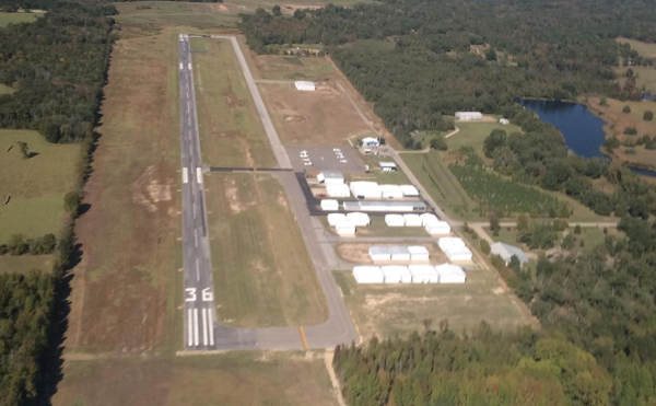
FUEL:  

 100LL JET-A
SELF SERVE FUEL AVAILABLE 24 HRS.

 
WoodCountyAirport copy